
COUNCIL INFORMATION
Council Secretary
0742395545
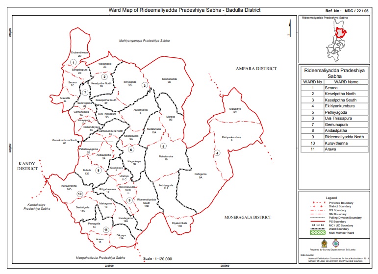
Located in Badulla District of Uva Province, Ridhimaliyadda Pradeshiya Sabha jurisdiction has an area of 430.03 square kilometers, and there are 11 constituencies, 42 village officer domains and 169 villages in that administrative jurisdiction. A population of 63,144 belonging to 18,315 families lives here. They belong to all three ethnicities, Sinhala, Tamil and Muslim. Their literacy rate is 80%.
Employment in the area is 58% of the population. For that, employment in the leading agricultural sector contributes 30% to the population and 52% to employment.
Accordingly, for the welfare, comfort and enjoyment of the people living in the area, the Ridhimaliyadda Divisional Council, established under the Divisional Council Act No. 15 of 1987, controls, administers and streamlines public health, public utility services and public roads.
The beginning of the local council and its evolution till now
In marking the beginning of Ridhimaliyadda local council, the first step was established as a village council. Then the work of the council was carried out under a special commissioner, where the work of the relevant position is led by a deputy governor. In 1991, the Ridhimaliyadda local council was formally established, where Mr. HM Punchi Banda became the Honorary Chairman representing the United National Party.
With the end of his term of office, H.M. Mr. Upali Senaratne is appointed, followed by W.W.M. Mr. Karunasundara, H.M. Mr. Upali Senaratne, H.A. Mr. Nandasena will represent the United National Party and become the Honorary Chairman.
Chairman’s name
Year
Mr. W.M.Karunarathna
1987
Mr. H.M.Punchibanda
1991
Mr.H.M.Upali Senarathna
2000
Mr. H.A.Nandasena
2008
Mr. Y.M.Karu Weerarathna
2012
Mr, J.M.Nishantha Kumara Jayasundara
2018
Mr,W.M.N.Wikramasekara
2025
1. Province - Uva
2. Administrative District - Badulla
3. Regional Secretariat - Ridhimaliyadda
4. Constituency - Mahiyangana
5. Village Officer Area - 42
6. Number of Villages - 169
7. Total Area Extent - 430.03 sq. km
8. Topography - Average height of plains above sea level
is 5 m, isolated ridges
extend up to 390 m.
9.Climatic Information - Dry Zone September to February
Monsoon Rainy Season Average
Rainless
Average Annual Temperature 23.9 ˚C
Average Annual Rainfall mm. 1531.1
10.Demographic Information -
Total Population - 64302
Female - 32533 Male - 31769
Population Density - 144.2 per sq km
Total Number of Families - 19127
Population Composition -
Sinhala - 64042
Tamil - 234
Sri Lankan Yonaka - 04
Malay - 18
Other - 04
11.Population by Religion -
Buddhist – 64040
Hindu - 234
Catholic - 24
Islam - 04
12.Employment - Employment Sector Number of Persons
State Sector 4253
Semi State 615
Private sector 4848
Agriculture 16336
Self employment 1645
Foreign employment 200
Temporary employment (hire) 3590
Total 31487
13.Land consumption pattern (ha)
Paddy 9424.3
Tea 02
Rubber 50.25
Coconut 499.5
Garden 5549.5
Other crops 2538.75
Forests 5689.68
Reservoirs
651.6
Uncultivated land 1200
Other 12122.42
Total 43007
14. Facilities in the jurisdiction
I. Hospitals and Dispensaries
Akiriankumbura
Hospital
Ridhimaliyadda
free Ayurvedic Dispensary
Andaulpatha Ayurvedic Dispensary
II. Schools and Colleges
National School - 01
Central High Colleges - 01
High Colleges - 07
Junior Colleges - 26
Piriven - 00
Preschools - 63
Number of Students - 12690
Literacy - 80%
G.E.C. Passed in Sapele - 11650
Passed in Aposa U. Passed - 6304
III. Financial Institutions
Regional Development Bank - Ridhimaliyadda
Rural Bank - Ridhimaliyadda, Thissapura
Samurdhi Bank - Gamunupura, Adaulpatha, Uraniya
IV. GOVERNMENT INSTITUTIONS
Ridhimaliyadda Regional Council, Andaulpatha
Regional Secretariat Ridhimaliyadda
Agricultural Service Center Ridhimaliyadda
Mahaweli Authority - Uraniya
Veterinary Office - Uraniya
Public Health Officer Office - Uraniya
Public Library - Ridhimaliyadda
Assistant Surveyor Superintendent Office Adaulpatha
Divisional Education Office - Aadaulpatha
Police Station – Ridhimaliyadda
Agricultural Center - Nagadeepa
National Youth Service Center - Orubadiwewa
Regional Development Bank - Ridhimaliyadda
Cultural Center - Ridhimaliyadda
Vidatha Center - Uraniya
Rural Hospital - Akirion Kumbura
District Hospital - Uraniya
15.Jalasha -
Nagadeepa - A.Ft. 23833
Demodara - A.Ft. 1855
Dehigama - A.Ft. 1620
Morana -
Minor Irrigation Tanks - 13
16.Road System Road Km.
A 6
B 9
C 15
D 12
E 163
Adipara 293
17. Special places in Bala area -
Senasungala Viharaya - K.P. 2nd century
Olagangala Temple - BC. 3rd century
Nagadeepa temple - BC. 2nd century
Murungagala (Talawegama) - BC. 2nd century
Tangolla (Kandubedda - 2nd century AD)
Dankumbura Raja Maha Vihara - 1st century AD
Ridhimaliyadda Raja Maha Vihara
Ridhimaliyadda Regional Council General Information
Community Halls
Demodara Community Hall
Council owned Ayurvedic Dispensaries
Ridhimaliyadda Free Ayurveda Dispensary
Number of Burial Grounds owned by the Council - 60
Number of Tube Wells owned by the Council - 114
Number of Public Wells owned by the Council - 33
Information about Shops owned by the Council
Water Spring - 36
Akirian Field - 10
Ridhimaliyadda - 03
Array - 02
Orubandivewa - 02
council owned weekly markets
Andaulpatha weekly market - Tuesday
Keselpotha weekly market - Wednesday
Gamunupura Week Market -
Libraries in the Council area on Thursday
Ridhimaliyadda Public Library Public
Toilets owned by the Council
Andaulpata Public Toilet
Ridhimaliyadda Public Toilet
Keselpotha Public Toilet
Pre-schools owned by the Council
Dikkendaya Samagi Pre-school
Council owned playgrounds
Gamunupura Public Stadium